Sunday, August 26, 2012

A Day in the Life of a Caucasian Adventure


My watch alarm has been set to 6:30am since arriving in Georgia. It seems to be our sweet spot for decent rest, cool morning riding and long days on the bike. Our goal every evening is to camp near water so we can clean the road off at the end of one day, and fill our coffee pot at the beginning of the next. With little exception we rise with the sun and soak up lazy cups of silty Turkish jo and oatmeal with the assistance of Chris's handy Primus camp stove. Our campsites are mostly in the middle of nowhere, but we ask permission when we end near private property and have yet to be turned down. This has landed us lakeside, tucked on the lee side of 12 foot hay mounds, at the base of glaciers in the middle of forested paradise, and smack in the middle of cow pasture. Our tent is a single poled, floor-less shelter that most closely resembles a circus tent. It fits three people and gear, or four in a pinch.

After breaking down our florescent tee-pee, we load the bikes, consult one of our numerous maps (paper and electronic) to get a sense of distance and elevation, and hit the road. We have made a point of staying off the main roads- it generally makes for  less monotonous riding, we end up steeping ourselves in the unexpected (dead ends, massively rutted roads, etc.), and it's just plain fun to make it up as we go. We do well enough by asking locals about route advice, particularly when none of our maps agree. Communication boils down to a game of charades. We use "sign language" and very limited Georgian and Russian to get everything from directions and simple information about food and water, to highly advanced requests for super glue, bolts and flashlights. The gesticulation that comes along with this does not fail to entertain. Our biggest challenge is convincing people we want to ride the "bad" road rather than asphalt. This is also entertaining because 95% of the country's roads fall into that "bad" category and we have enjoyed a small majority of them.

Our afternoons are never the same. We snack, we rest in the shade when needed, we suffer through rough road a lot, but we have also adopted a "yes" policy that makes each day unique. By never saying no to anything that is offered to us, we have spent a lot of our time sharing drinks, food, and swimming holes; we have enjoyed tours of aquaculture plots and hotels, accepted overnight stays at cement factories and glitzy wedding halls, and entertained lots and lots of awkward chats. We are definitely not just moving from A to B, but rather bouncing along with the unintended and unanticipated.


Over the past 23 days we have managed to cover the Svaneti region, Kasbegi and the Military Highway, and the Borjomi-Samtskhe region. We're in the geyser-laden land of Borjomi proper now, and headed into the national park for a three day trek. Our last days will be spent in the Kakheti region, where Georgians claim wine was born. Cheney is our wine guru in motion and on his way to intern in Burgundy in just a week or so. Chris and I will have the benefit of enjoying the area through his expertise. So we'll wrap up with wine and castles and then move in three very different directions. More on those plans and pictures very soon...
Saturday, August 11, 2012

Line in the Pebbles

Crossing borders is a funny funny thing. There is something particularly interesting about crossing borders over land. We passed through a stack of waiting vehicles, shuffled through a line of passport holders, then visa holders (in a mercifully air conditioned building) and seemingly passed through a portal with Turkey on one side and Georgia on the other. All there is to separate these worlds is a line in the Black Sea pebbles. There are no insurmountable mountains or bodies of water, none of the barriers that keep culture and histories separated. Even more, this particular border has changed many times- having been both Georgia and Armenia centuries ago. The point...the point is that once we crossed that last air conditioned threshold- despite proximity, despite crisscrossing history- we were in a very different place. The attitudes (mostly), which translated to traffic conditions changed instantly. There is a clear bravado or machismo. Road maintenance and fuel standards (already alluded to) took a dive- signs of economic differences to be sure. Georgia is more or less indifferent to us, she has given us a colder than expected shoulder in the human kindness department. I have speculated about this quite a bit and guessing around it is just fruitless. Positive note: Georgia is stunning!

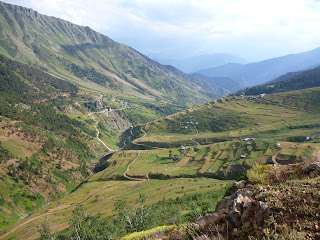
We have just spent the last week or so biking a loop through the Svaneti region. It is known as the only "kingdom" to thwart all attempts of past conquerors. The mountains are intimidating indeed! We started just north of Zugdidi, zagged off course to camp and bike in the Dolra valley at the base of Mt. Ushba, and made our way to Mestia. After a half day of replenishing our food stores and soaking in a little bit of  traditional Svan food and architecture in the regional capital, we made our way over the pass toward Ushguli. The pavement ended and the mud (helped by a healthy amount of rain) started after Mestia. Traffic all but stopped as the roads are rough and people are sparse. Carcasses of Svan towers and stone houses dot hillsides and valleys along the way, but the landscape is mostly dominated by green foothills and glacier flanked peaks. The descent from the last pass was a dooooozy- 80k of semi-controlled, bone rattling, blissful riding that dropped us through head-high patches of (mostly) purple wildflowers and into a new rain soaked river valley.

We are in Tbilisi for a few short hours to set up bike boxes for the trip home, stock up on food, and clean ourselves. By tonight we'll be on our way up the Military Highway to ogle the Greater Caucus range for anther week of quad busting, heart exploding riding and hiking. 

Sunday, August 5, 2012


Going Roadless

We made our way from Yusufeli to Yaylarlar at the base of Mt. Kackar (the summit is at about 13,000 ft). The ride was rough on Chris who was still nursing some serious stomach woes, but was otherwise some of the most picturesque and peaceful riding we've done. The narrow dirt road stayed close to the river, keeping the grade mellow and the air cool. We shared our campsite and some dinner conversation with two other travelers- the first tourists we've manage to meet.
Thunder and lightening storms are daily occurrences at this elevation (about 9,000 ft). The landscape is wet and green with vibrant patches of pink, yellow and purple wild flowers. We took the hiking mildly without any real hopes of summiting the peak. Chris is flying half-mast after days of eating little to nothing and our legs are still very much earning the elevation. With a day of extreme climbing ahead and thick clouds obscuring the view from the top, we are all willing to stand down temptation. The hike meandered through a "u" shaped valley lined by folds of water carved slopes and topped with a spine of jagged rock spires. We topped out at a snow fed lake and managed to scramble up a side slope for some more than satisfactory boulder trundling.

The following few days took us back down the valley 25k to the junction to Olingar. Our hope was to find the road over the pass and make our way back down to the Black Sea at Arhavi. We asked several people about the road (resulting in one thoughtfully hand drawn map) with many different suggestions returned. In the end we found it wise to consult the locals as we neared the various junctions. Despite the fact that we are carrying several maps, there are no clear routes for this leg of the journey. Some roads exist on one map and not the other. The Google road and relief maps we have saved on the Ipod don't have any information on this region- the roads are new and mostly unused and we found out why. Let's just say that the going was slow and the views were well earned. We biked through several showers on pass day and made our way over the top in time to catch the onset of a heavy rainstorm. The following morning was dedicated to drying out gear and maintaining the bikes- including cleaning the drivetrains and tightening break cables for the steep and bumpy ride down. We made it 10k down the road before running into a very jolly group of guys building cliff side stone chalets. They invited us to take a look around, which progressed to tea, then lunch and an eventual offer for a ride down to Arhavi. After flatting during the first 10k and losing most of the feeling in my fingers from squeezing the breaks, I was more than happy to accept. Man o man was this a good decision on all of our parts. The road was extremely rough with deep rocky ruts and enough sharp rocks and steep drops to guarantee more time consuming punctures. The 50k took us 3.5 hours in the truck and would have likely taken us an extra day to descend. None of us shy away from a good adventure, but this one would have been more painful than necessary. The views...the views were mostly obscured by the thick layer of cloud we meandered through for the majority of the ride. Every once and a while though the clouds would part just enough to see the extreme vertical drop. These hills very literally dive into the sea. It is impossible to see the top from the bottom, or the bottom from the top. Stands of trees intermittently appeared through the clouds, but looked be floating as it was, from our angle, completely impossible to see where they were rooted. We rode, three abreast, in the back bed of a massive red truck with our bikes tightly bungied to the side rails. We arrived in Arhavi just before sunset and just in time to inhale a communal trough of ice cream before spinning (sea-legged) on to Hopa.

We crossed the border to Georgia yesterday and are spending the day in Batumi before busing through the hot plains and on to the foothills of the Greater Caucus mountains. Georgia is a whole new animal with narrower roads, faster drivers, dirtier tailpipes and a whole new set of communication challenges. Wish us luck!